Showing 64 items matching tourist track
-
 Cockatoo History & Heritage Group
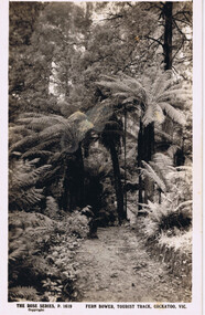
Postcard, Rose Stereograph Co, Fern Bower, Tourist Track, Cockatoo, VIC
... Fern Bower, Tourist Track, Cockatoo, VIC...Tourist Track...Cockatoo's Tourist Track featured in many postcards...-and-the-dandenong-ranges Postcard Fern Bower, Tourist Track, Cockatoo, VIC ...Cockatoo's Tourist Track featured in many postcards that were produced. It was an important attraction for the many holiday makers that came to Cockatoo in the early part of last century.The Tourist Track extended along the Cockatoo Creek, crossing the creek in various parts. It seemingly followed the creek until it ended in the vicinity of Mountain Rd and started near the swimming pool.Original Postcard - The Rose Series P 1619 cockatoo creek, tourist track, rose series postcard, cockatoo victoria -
 Mt Dandenong & District Historical Society Inc.
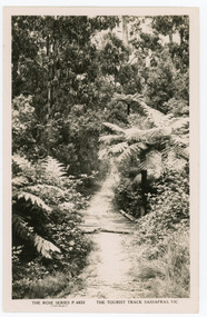
Photograph, The Tourist Track, Sassafras.Vic, c1920
... The Tourist Track, Sassafras.Vic...The tourist track running alongside the creek from... a section of the Tourist Track in Sassafras surrounded by tree ferns...-and-the-dandenong-ranges Photograph Photograph The Tourist Track ...The tourist track running alongside the creek from Sassafras Mechanics’ Hall to Emerald. In the early 1900s the track started at Rostrevor Guest House.Black and white Rose Series postcard P. 4832 showing a section of the Tourist Track in Sassafras surrounded by tree ferns and bush.On Reverse POST CARD A Real Photograph. Produced in Australia.sassafras, rose series, postcard, track -
 Mt Dandenong & District Historical Society Inc.
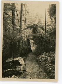
Photograph, Tourist Track, Sassafras. Vic, c1920
... Tourist Track, Sassafras. Vic....The tourist track running alongside the creek from... a log bridge along a tree fern lined section of the Tourist...-and-the-dandenong-ranges Photograph Photograph Tourist Track, Sassafras. Vic ...The tourist track running alongside the creek from Sassafras Mechanics’ Hall to Emerald. In the early 1900s the track started at Rostrevor Guest House.Black & White postcard P1501 from the Rose Series. Shows a log bridge along a tree fern lined section of the Tourist Track.On reverse - POST CARD A Real Photograph. Produced in Australia.rose series, sassafras, track, postcard, mechanics' hall -
 Mt Dandenong & District Historical Society Inc.
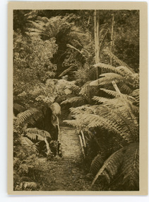
Photograph, Tourist Track, Sassafras, c1913
... Tourist Track, Sassafras...On reverse - Tourist Track, Sassafras...-and-the-dandenong-ranges Photograph Tourist Track, Sassafras Small b & w ...This set of 8 photographs was produced by the Rose Stenograph Co. c1913 to be included in photograph albums. They show tourist scenes of Sassafras and surrounds. The photographs were donated by a family in Western Australia whose parents lived in Sassafras c1918.Small b & w photograph from a series of 8 showing scenes from Sassafras produced by the Rose Stenograph Co. c1913.On reverse - Tourist Track, Sassafrassassafras, bridge, footbridge, rose series -
 Mt Dandenong & District Historical Society Inc.
Photograph, Tourist Track, Sassafras, c1913
... Tourist Track, Sassafras...On reverse - Tourist Track, Sassafras...-and-the-dandenong-ranges Photograph Tourist Track, Sassafras Small b & w ...This set of 8 photographs was produced by the Rose Stenograph Co. c1913 to be included in photograph albums. The show tourist scenes of Sassafras and surrounds. The photographs were donated by a family in Western Australia whose parents lived in Sassafras c1918.Small b & w photograph from a series of 8 showing scenes from Sassafras produced by the Rose Stenograph Co. c1913.On reverse - Tourist Track, Sassafrassassafras -
 Mt Dandenong & District Historical Society Inc.
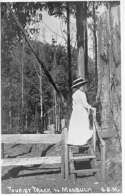
Photograph, Tourist Track To Monbulk, c1917
... Tourist Track To Monbulk...Tourist Track To Monbulk G.G.M....-and-the-dandenong-ranges Photograph Tourist Track To Monbulk Miss Gwen ...Miss Gwen Roberts, daughter of John and Roberta Roberts of Sunnyside, South Sassafras (now Kallista), climbing a style on the Monbulk Track.Tourist Track To Monbulk G.G.M.gwen roberts, monbulk track -
 Mt Dandenong & District Historical Society Inc.
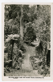
Photograph, The Tourist Track, Sassafras. Vic, c1920
... The Tourist Track, Sassafras. Vic...The tourist track running alongside the creek from...-and-the-dandenong-ranges Photograph Photograph The Tourist Track, Sassafras ...The tourist track running alongside the creek from Sassafras Mechanics’ Hall to Emerald. In the early 1900s the track started at Rostrevor Guest House.Black and white photograph. Rose Series P. 4825 postcard showing a footbridge along a Tourist rack surrounded by bush and tree ferns.rose series, rostrevor, mechanics' hall, sassafras, track -
 Mt Dandenong & District Historical Society Inc.
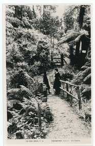
Photograph, Sassafras Gully, Victoria, c1920
... The tourist track running alongside the creek from... of steep steps can be seen above them. The tourist track running ...The tourist track running alongside the creek from Sassafras Mechanics’ Hall to Emerald. In the early 1900s the track started at Rostrevor Guest House.Black and white copy of Rose Series Post card P. 74 showing two young women standing on a footbridge at Sassafras Gully. A set of steep steps can be seen above them.rose series, track, footbridge, bridge, sassafras -
 Halls Gap & Grampians Historical Society
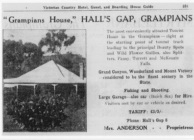
Flyer - B/W, C 1924-25
... ," Hall's Gap, Grampians, The most conveniently situated Tourist... at the starting point of tourist track leading to the principal Beauty ...Tariff L 3/3 Mrs Anderson was proprietress "Grampians House," Hall's Gap, Grampians, The most conveniently situated Tourist Home in the Grampians - right at the starting point of tourist track leading to the principal Beauty Spots and Wild Flower Gullies, also Splitters, Pansy, Turrett and McKenzie Falls Grand Canyon, Wonderland and Mount Victory considered to be the finest scenery in the State. Fishing and Shooting. Large Garage - also Car (Buick Six) for Hire. Visitors met by car of vehicle as desired. Phone Halls Gap 8Detail of advertisement for Victorian Country Hotel Guest and boarding house Guide with photo of original housemedia, flyers, accommodation, grampian house -
 Mt Dandenong & District Historical Society Inc.
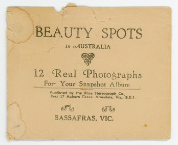
Photograph, Beauty Spots in Australia. Sassafras, c1913
... TOURIST TRACK, SASSAFRAS, VIC. Photograph 32g - THE ROSE SERIES P... - THE ROSE SERIES P. 1501 TOURIST TRACK, SASSAFRAS, VIC. Photograph ...This set of small photographs was produced by the Rose Stenograph Co. c1913 to be included in photograph albums. The area known as South Sassafras, was opened up for settlement in 1893 and the name was changed to Kallista in 1925.A small, paper envelope containing 12 photographs of Sassafras that are reproductions of Rose Series postcards. There are 10 different photographs, 32a and 32c have doubles.Envelope : BEAUTY SPOTS in AUSTRALIA 12 Real Photographs For Your Snapshot Album Published by the Rose Stenograph Co. Rear 17 Auburn Grove, Armadale, Vic 3.E.3 SASSAFRAS, VICTORIA Photograph 32a - THE ROSE SERIES P. 905 CLEMATIS AVENUE, SHERBROOKE, VIC. Photograph 32b - THE ROSE SERIES P. 1603 THE CASCADES, SASSAFRAS, VIC. Photograph 32c - THE ROSE SERIES P. 204 PANORAMA AT SASSAFRAS, VIC. Photograph 32d - THE ROSE SERIES P. 4046 MAIN ROAD, SASSAFRAS, VIC. Photograph 32e - THE ROSE SERIES P. 1502 SASSAFRAS CREEK, SASSAFRAS, VIC. Photograph 32f - THE ROSE SERIES P. 1501 TOURIST TRACK, SASSAFRAS, VIC. Photograph 32g - THE ROSE SERIES P. 4244 TOURIST TRACK, SOUTH SASSAFRAS, VIC. Photograph 32h - THE ROSE SERIES P. 2725 CLEMATIS AVENUE, SHERBROOKE, VIC. Photograph 32i - MAIN ROAD, SASSAFRAS, VIC. Photograph 32j - THE OLINDA - SASSAFRAS ROAD, VIC. rose series, rose series, sassafras, sherbrooke, sassafras creek -
 Lorne Historical Society
Pamphlet - Tourist Brochure, Lovely Lorne
The Victorian Railways promoted tourist destinations around Victoria. A folded paper tourist brochure about Lorne The front cover is a coloured painting of Lorne from above the Erskine River towards the main beach. , on the back is a black and white sketch tourist map of the roads, tracks and beauty spots. Inside the first fold are 6 black and white photographs, Cumberland River, Mt St George, Phantom Falls, Cumberland Cliffs, Teddy’s Lookout, leafy walk towards the pier. Inside contains written descriptions of the highlights of Lorne and six black and white photographs, four general views of Lorne, Lover’s Walk, Erskine Falls . souvenirs, victorian railways, publicity -
Lorne Historical Society
Pamphlet - Tourist pamphlet Lorne, Lorne Victoria Australia
Victorian Railways printed a series of brochures publicizing holiday destinations.A folded paper souvenir pamphlet. The cover is a colored picture of Lorne from Scotsman’s Hill with two bathing suited young women in the foreground, and a blurb extolling the virtues of Lorne. On the back is a red, yellow and blue map of Lorne and district. Inside are eight black and white photographs of Lorne attractions,; the Main Street, tennis courts, Erskine River, walking tracks and the George River with the phrase ,” The resort that embraces everything for the perfect holiday.”souvenirs, pamphlets, victorian railways, -
Marysville & District Historical Society
Document (Item) - Newspaper article, The Argus, New Tourist Road. Marysville to Wood's Point Magnificent Forest Scenery, 02-1924
A newspaper article regarding the opening of the Marysville-Wood's Point Road in February 1924.A newspaper article regarding the opening of the Marysville-Wood's Point Road in February 1924. The Marysville-Woods Point Road was originally part of the Yarra Track, constructed in the early 1860s to provide access between Healesville and the Woods Point Goldfields. Despite the steep terrain and engineering difficulties, the Yarra Track soon became a busy route used by pack horses, horse-drawn drays, and wagons. Today this sealed mountain road is a popular scenic drive between Marysville and Warburton.marysville-wood's point road, yarra track, healesville, wood's point goldfields, warburton, the argus -
 Marysville & District Historical Society
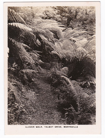
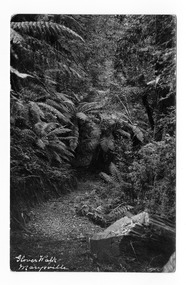
Photograph (item) - Black and white photograph, Rose Stereograph Company, Glover Walk, Talbot Drive, Marysville, 1913-1967
An early black and white photograph of Glover Walk which was off Lady Talbot Drive in Marysville, Victoria.An early black and white photograph of Glover Walk which was off Lady Talbot Drive in Marysville, Victoria. Glover Walk was named after Hannah Elizabeth Glover, a nurse who in 1908 established the Kerami guest house in Marysville. She became an active member of the local tourist association and was acclaimed for her 'energy and enterprise' (Riverine Herald, 31 December 1915). In this capacity she successfully lobbied government to fund walking tracks in the district, one of which was given her name. The photograph was also used to produce the Rose Series postcard P. 2312.marysville, victoria, photograph, glover walk, hannah elizabeth glover, lady talbot drive, talbot drive, p. 2312, rose stereograph company, souvenir, rose series postcard, marysville tourist association, kerami guest house -
 Marysville & District Historical Society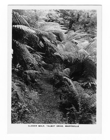
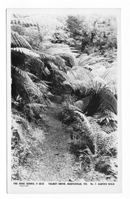
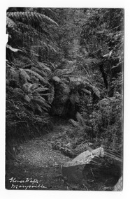
Postcard (item) - Black and white postcard, Rose Stereograph Company, Talbot Drive, Marysville, Vic. No. 7, Glover Walk, 1913-1967
A postcard in a series produced by the Rose Stereograph Company in Victoria, Australia as a souvenir of Marysville.An early black and white photograph of Glover Walk which was off Lady Talbot Drive in Marysville, Victoria. Glover Walk was named after Hannah Elizabeth Glover, a nurse who in 1908 established the Kerami guest house in Marysville. She became an active member of the local tourist association and was acclaimed for her 'energy and enterprise' (Riverine Herald, 31 December 1915). In this capacity she successfully lobbied government to fund walking tracks in the district, one of which was given her name. This postcard was produced by the Rose Stereograph Company as a souvenir of Marysville.POST CARD The "Rose" Series/ De Luxe A Real Photograph/ Produced in Australia Published by the Rose Stereograph Co.,/ Armadale, Victoria.marysville, victoria, photograph, glover walk, hannah elizabeth glover, lady talbot drive, talbot drive, p. 2312, rose stereograph company, souvenir, rose series postcard, marysville tourist association, kerami guest house -
 Marysville & District Historical Society
Postcard (item) - Black and white postcard, Glover Walk Marysville, Unknown
An early black and white photograph of Glover Walk which was off Lady Talbot Drive in Marysville, Victoria.An early black and white photograph of Glover Walk which was off Lady Talbot Drive in Marysville, Victoria. Glover Walk was named after Hannah Elizabeth Glover, a nurse who in 1908 established the Kerami guest house in Marysville. She became an active member of the local tourist association and was acclaimed for her 'energy and enterprise' (Riverine Herald, 31 December 1915). In this capacity she successfully lobbied government to fund walking tracks in the district, one of which was given her name.POST CARD PLACE/ POSTAGE/ STAMP/ HERE Marysville/ Dear Kath/ We managed to get here safely/ after a lovely trip, but it/ has done nothing but rain/ since we arrived. It looks/ as if it is going to clear up/ a bit & perhaps we will/ be able to get a few fish. Being over in this spot I/ am unable to send you/ the weekly suply of ??????/ so please sweetheart let me/ off this time. I hope to/ see you all again soon./ Love + kisses from your Valmarysville, victoria, glover walk, hannah elizabeth glover, lady talbot drive, talbot drive, souvenir, marysville tourist association, kerami guest house, postcard -
 Marysville & District Historical Society
Postcard (item) - Black and white postcard, Glover Walk Marysville, Unknown
An early black and white photograph of Glover Walk which was off Lady Talbot Drive in Marysville, Victoria.An early black and white photograph of Glover Walk which was off Lady Talbot Drive in Marysville, Victoria. Glover Walk was named after Hannah Elizabeth Glover, a nurse who in 1908 established the Kerami guest house in Marysville. She became an active member of the local tourist association and was acclaimed for her 'energy and enterprise' (Riverine Herald, 31 December 1915). In this capacity she successfully lobbied government to fund walking tracks in the district, one of which was given her name.POST CARD PLACE/ POSTAGE/ STAMP/ HERE Marysville/ Jan 29th/18 Dear Lillie/ We arrived here safely on Sat after a very hot/ drive, we rested at several places on the way. The/ road is very heavy, the scenery is extremely/ beautiful, it repay one to see the beauty./ I have never seen such scenery. Weather/ today is very oppressive, it has rained all/ this morning. We leave for home tomorrow Wed./ I hope you are having a very enjoyable time/ Love from ??? Jerome ???? Sonya + Mothermarysville, victoria, glover walk, hannah elizabeth glover, lady talbot drive, talbot drive, souvenir, marysville tourist association, kerami guest house, postcard -
 Kiewa Valley Historical Society
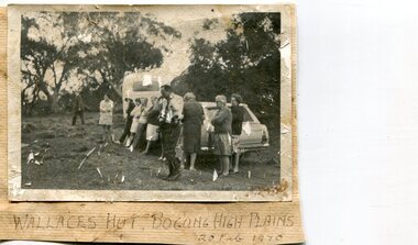
Photographs x 2- Bus tour of Wallaces Hut, 20/02/1970
Wallace's hut was built in 1889 and is probably the oldest surviving hut on the high plains of north-east Victoria. It was built in six weeks by Irish immigrant brothers Arthur, William and Stewart Wallace among old snow gums on a grassy plain above the snowline. The brothers held grazing leases on the High Plains and the hut was built to provide shelter for the cattlemen working there. It is probably the oldest hut on the Victorian high plains. It is part of the early history of hydroelectricity in the state and has links with early SEC meteorological data recording in the area Apart from its historical significance, Wallace’s Hut is a popular stop for tourists and photographers and is the starting point for the Wallace’s Heritage trail, which is a popular and well used hiking track, by locals and visitors alike.2 black and white photographs mounted on buff card. Photos taken during a bus trip to Wallace's Hut on Feb. 20, 1970 1. Group of local Kiewa Valley residents on a bus tour to Wallace's hut 2. Group of adults and children pictured outside Wallace's hut1. Handwritten in black ink on bottom of photo 'Wallace's Hut, Bogong High Plains, 20 Feb, 1970 2. No markingswallace's hut, bogong high plains, bush walking, cattlemen -
 Eltham District Historical Society Inc
Photograph, Entrance to Shire of Eltham Memorial Park, Garden Hill, Eltham-Yarra Glen Road, Kangaroo Ground, c.1923
View to south-east from Shire of Eltham Soldiers' Memorial Park showing the carriageway from the road to top of Memorial Park. Accompanying notes state that the entry gate was put in place in May 1921. Eltham and Whittlesea Shire Advertiser and Diamond Creek Valley Advocate Fri 21 May 1920 p 2 reported: Kangaroo Ground Memorial Park "It was decided to arrange for a working bee on Saturday, 29th inst., for the purpose of forming and gravelling the track leading to the Park, and of carrying out other necessary works." A history summary of the Shire of Eltham Soldiers’ Memorial Park • The summit at Garden Hill was a popular tourist lookout and picnic spot from the 1880s. Virtually the entire Shire of Eltham and beyond could be viewed from this location. • A local farmer, Mr Walter A. D. Wippell is credited as being the first to propose the idea of a war memorial park and offered £50 towards the purchase of the land. • The earliest public reference to this project is to be found in the local Advertiser newspaper edition of August 9th, 1918. A report of the August Council meeting records the Eltham Shire President, Cr. Robert White, saying: "some time back it was proposed that the Council obtain and place on an Honour Board in the Council Chamber [at Kangaroo Ground] containing names of the lads who had enlisted. Just recently however, it had been suggested that a more fitting memorial would be the obtaining of a piece of land on the summit of Garden Hill, Kangaroo Ground, and the formation of a memorial park in which a monument could be erected to represent the whole of Shire. If a couple of acres could be obtained a gentleman had promised to donate 50 pounds, and another one would fence it, and other contributions, he was sure, could be obtained." • Councillors were favourable of the proposal and the President, Shire Secretary and Shire Engineer were deputised to wait on Messrs Mess Bros. (the owners of the Garden Hill farm) and ascertain if they would gratuitously give the land. The Mess Bros. land adjoined the farm/stud of Mrs Fanny White (Cr Robert White’s mother), daughter of Andrew Harkness who established their property on Garden Hill around 1846. • Access to the land came in February 1919 when several Councillors and the Shire Engineer surveyed the actual two acres of '5 chains along the road and 4 chains deep'. The Engineer volunteered his services free to do this task. The Mess brothers however demanded £100 per acre but eventually agreed to take £50 per acre. • Entry from the Kangaroo Ground-Yarra Glen road was seen to be a problem and Mrs. White, who owned the land beside the park, was asked to donated a triangle of her property to allow this access. • By September 1919 returned soldiers were employed by the Shire and volunteers were called to clear the hilltop by ploughing up the rocks and clearing the area, the fencing was put into place and in May 1921 the Council erected three gates, within an archway, at the entrance to the drive and pathway to the summit. • Public subscriptions were sought through the Advertiser newspaper to beautify the site. The views of the Curator of the Melbourne Botanical Gardens were sought as to the ‘class of ornamental trees most suitable for planting in the Park area”. • The Memorial Park or Shire of Eltham Soldiers’ Memorial Park was officially opened by Mr. W.H. Everard, M.L.A., 3 September 1921. • In 1922 plans were made to place a War Memorial in the Park. Funds were donated by the Council of £250 and a challenge to the community, to match this money with contributions was met. • On Anzac Day 1923, 1,000 people gathered on the summit in the park for a memorial service. A much smaller group of about 50 people gathered around a newly constructed cairn and flagstaff in the afternoon of Anzac Day 1924 amidst rain and a squally southerly wind, the morning service being cancelled. • A meeting for those interested in establishing a War Memorial monument within the park was held in January 1924 and the Eltham Shire War Memorial League was formed and a design competition decided upon. • The Shire of Eltham War Memorial tower was built in 1926 at a cost of £1,023 and 5 shillings with locally quarried stone donated by Dr Ethel and Professor William Osborne. It was formally known as the ‘Shire of Eltham War Memorial’ and was unveiled on 11 November 1926. The large bronze inscription above the entrance to the tower states: SHIRE OF ELTHAM WAR MEMORIAL THESE MEN DIED FOR THEIR COUNTRY 1914 IN REMEMBRANCE THIS TOWER WAS BUILT 1918 • The Caretaker’s hut was built in 1927 with left over from the tower construction. • A returned soldier was appointed to act as caretaker for the memorials. Tiny Carrol, a huge man, was the first caretaker and lived in the stone hut. There was a push to have alterations made at one stage to provide additional rooms for a married caretaker but was rejected. • A new Caretaker Cottage was built in 1951 at a cost £2,500. The cottage had been subjected to raids by thieves three times during construction until a guard from the Returned Servicemen’s League was posted until its opening. • The War Memorial tower was re-dedicated by Sir Dallas Brooks on 8 November 1951, unveiling new bronze plaques containing the names of those who fell during the Second World War. Sir Dallas also officiated the opening of the new Caretaker’s Cottage. • A toilet block was built in 1965. • A further dedication of the Shire of Eltham War Memorial tower took place 11 November 2001 to recognise the men who fell in subsequent campaigns up to and including Vietnam. • Four land titles are involved: o The purchase of the two acres from owners Ruth Gosling, Alexander Mess, James Johnson Mess and Joseph Mess is recorded in two actions, the first being the payment of £100 for the two acres, the second showing that the Shire of Eltham did not get a transfer of title until 14th January 1952. o The access land donated by Mrs. Fanny White is dated 26 February 1924. A further need to widen the entry came after the deepening of the road cutting and another land donation was given by Sir Herbert Gepp, title dated 15th May 1952. This would have been about the time he sold off the former White ‘Garden Hill’ property. o The land reserve to increase the area and possibly allow a circuit road to be put in place on the western side of the park was purchased by the Shire of Eltham, title dated 16th February 1973. Rare photograph of the entrance to the Shire's Memorial Park during early stages of development prior to the erection of the Shire of Eltham War MemorialSepia photograph printed with white border with slight crack lower left hand corner and three significant vertical cracks fanning from lower centre edge to upper edge Digitally enhanced version to minimise impact of crackseltham-yarra glen road, entrance gate, garden hill, kangaroo ground, shire of eltham memorial park, shire of eltham war memorial, kangaroo ground war memorial park -
 Puffing Billy Railway
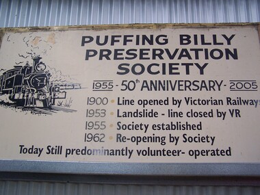
Puffing Billy Preservation Society 50th Anniversary Station Sign, 2005
Puffing Billy Preservation Society 50th Anniversary sign This is the large poster board that was erected at Lakeside to celebrate the 50th Anniversary of the Puffing Billy Preservation Society in 2005. Established in 1955, the Puffing Billy Preservation Society was formed to operate the narrow gauge trains between Upper Fern Tree Gully and Belgrave following the successful Young Sun specials. With the conversion of the Upper Fern Tree Gully to Belgrave line to broad gauge track, the Puffing Billy Preservation Society was the instigator of restoring the Puffing Billy Railway from Belgrave to Menzies Creek in 1962, Menzies Creek to Emerald in 1965 and Emerald to Lakeside in 1975 and in association with the Emerald Tourist Railway Board, Lakeside to Gembrook in 1998. Historic - Puffing Billy Preservation Society - Station Sign - for the 50th Anniversary of the Preservation SocietyPuffing Billy Preservation Society 50th Anniversary sign Large rectangle metal sign - off white back ground with black lettering Puffing Billy Preservation Society 1955 - 50th Anniversary - 2005 1900 . Line opened by Victorian Railways 1953 . Landslide - Line closed by V.R 1955 . Society established 1962 . Re-opened by Society Today still predominantly volunteer - operated puffing billy, preservation society, station sign, 50th anniversary, lakeside station -
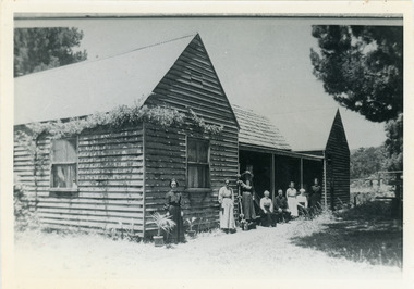 Mt Dandenong & District Historical Society Inc.
Photograph, "Shiloah" 1913
'Shiloah' was the home of Isaac Jeeves the younger - son of Isaac Jeeves the Valley Pioneer and brother of Ellis Jeeves. Isaac built this house himself using local timber he cut and split. It was ready for his marriage to Selina Leach of Bayswater in 1886. ‘Shiloah' was enlarged to take guests in the early 1900s. It was situated close to a beautiful fern gully and Isaac and his family capitalised on this by setting out walking tracks through the ferns. They charged 1/- to walk through and this included afternoon tea in a garden setting. ‘Shiloah’ was a popular tourist attraction but the making of the Olinda Creek Road destroyed the fern gullies and, by the 1930s, it was all finished.Black and white photograph of wooden structure with two wings and a central verandah. Eight adults sitting or standing at the front.Handwritten on back by John Lundy-Clarke "Shiloah" 1913.isaac jeeves, isaac jeeves the younger, ellis jeeves, shiloah, guest house, guesthouse, selina leach, selina jeeves, olinda creek road -
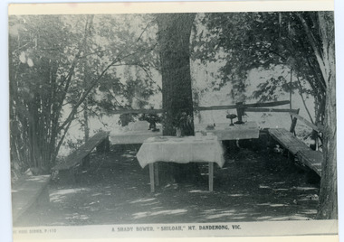 Mt Dandenong & District Historical Society Inc.
Photograph, Tea Tables at "Shiloah"
Originally the home of Isaac Jeeves, brother of Ellis Jeeves, ‘Shiloah’ was enlarged to take guests in the early 1900s. It was situated close to a beautiful fern gully and Isaac and his family capitalised on this by setting out walking tracks through the ferns. They charged 1/- to walk through and this included afternoon tea in a garden setting. ‘Shiloah’ was a popular tourist attraction but the making of the Olinda Creek Road destroyed the fern gullies and, by the 1930s, it was all finished. This photograph shows the tea tables at 'Shiloah' where Selina Jeeves and her daughter Elsie served afternoon tea to visitors.Black and white photograph taken from a Rose Series postcard showing tables set up in an exterior courtyard with bench seating.On front - Rose Series P. 170 A SHADY BOWER "SHILOAH" MT DANDENONG. VIC.shiloah, isaac jeeves the younger, guest house, afternoon tea, ferns, selina jeeves, elsie jeeves -
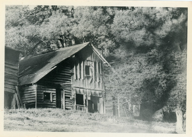 Mt Dandenong & District Historical Society Inc.
Photograph, Isaac Jeeves' Barn
Large barn built c1886 by Isaac Jeeves the younger on his property where the homestead 'Shiloah' stood. The barn was reputedly made from timbers split from only one messmate tree. Originally the home of Isaac Jeeves, brother of Ellis Jeeves, ‘Shiloah’ was enlarged to take guests in the early 1900s. It was situated close to a beautiful fern gully and Isaac and his family capitalised on this by setting out walking tracks through the ferns. They charged 1/- to walk through and this included afternoon tea in a garden setting. ‘Shiloah’ was a popular tourist attraction but the making of the Olinda Creek Road destroyed the fern gullies and, by the 1930s, it was all finished. John Lundy-Clarke grew up in the Kalorama/Mt Dandenong area and later in life (1972-74) began to write a comprehensive history of the area working from an original settlement map in an effort to cover all areas.Black and white photograph showing a large wooden structure surrounded by trees. Handwritten inscription on reverse by John Lundy-Clarke.Home of Isaac Jeeves the younger. Built about 1886 of timbers split from one messmate tree. Photo 1973isaac jeeves the younger, barn, kalorama, shiloah, messmate -
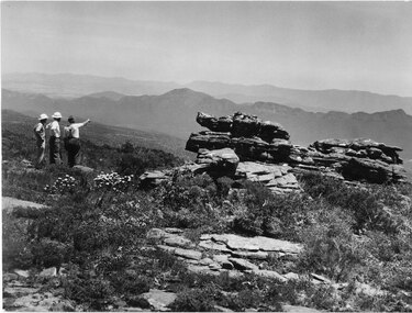 Halls Gap & Grampians Historical Society
Photograph - B/W, C 1960s
A track to the top of Mt William existed many years before, an all weather road was constructed in the early 1960s Not only did engineers and construction workers enjoy some spectacular scenery during "smokos" but so have thousands of tourists Some even experiencing the freezing gale force winds which greeting Major Thomas Mitchell and his party in July 1836sPhoto shows 3 men looking over to Wonderland Range from Mt William. Two men are wearing hard hats The third man a felt hat - he is pointing to a point in the distanceWMT (Wimmera Mail Times}access routes, walking track, roads, mount william -
 Orbost & District Historical Society
programs, 1961
The Snowy River Shire was a local government area in the Australian Alps region of New South Wales, Australia from 1939 until May 2016. It was named after the Snowy River that runs through it. Prior to 1936, it had been named as Dalgety Shire since establishment in 1906. This opening of the Monaro - Gippsland Road took place on 4th May 1961. There had long been a movement in Monaro for the construction of a road to connect Monaro and Gippsland, via Inglebyra and Black Mountain. The only track was for stock, made by pioneers many years ago, and it was very circuitous. It was stated at a meeting at Dalgety that the road would open up large areas for settlement for grazing, and for timber suitable for bridgé building. The road would assist stock deal ing between Monaro and Gippsland. It would also considerably shorten the distance from Victoria for tourists visiting Canberra and Kosciusko. A committee was formed to put the proposal before the Dalgety Shire Council in the 1930s.This item is a useful research tool.Four copies of a road opening program. It has black print on white. There are black / white photographs, historical details and details of the official opening.program monaro-road snowy-river-shire -
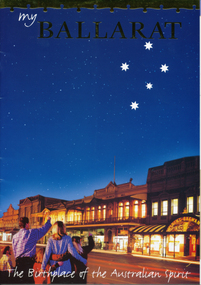 Ballarat Tramway Museum
Pamphlet, Ballarat Tourism, "My Ballarat, the Birthplace of the Australian Spirit", Nov/Dec. 1998
48 page, colour printed on glossy paper, Ballarat Tourism brochure designed for interstate and overseas tourist to make Ballarat, their destination. P13 associated with Steve Moneghetti's story of 'my Ballarat', including a photograph of tram 26, at Gardens Loop during a Begonia festival. Conductor in rear compartment of 26. Telephone box open, obscuring a BTM member standing by phone in uniform. P45 has City of Ballarat map, showing tramway and museum/depot. Track does not project beyond depot spur to Carlton St. Brochure features stories from Ballarat residents and visitors, including other district items, features and accommodation section.trams, tramways, ballarat tourism, city of ballarat, btm -
Southern Sherbrooke Historical Society Inc.
Information folder - Puffing Billy Tourist Railway
Information folder containing items pertaining to Puffing Billy. Contents: -article, 'Behind closed doors', the(melbourne)magazine, undated -article, 'Billy running out of puff, in need of more folding stuff', The Age, 14th Sep 2011 -article, 'Chinese delighted to ride rails on a slow train to Gembrook', The Age, 15th Sep 2011 -article, 'New pal for Puffing Billy', Mail, 27th Mar 2012 -article, 'Train trucked in and on track', Mail, 27th Mar 2012 -article, 'New engine on track for museum', 28th Mar 2012 -article, 'All steamed up over great race', Mail, 2nd May 2-12 -article, 'Billy welcomes funding boost,' Mail, 8th May 2012 -article, 'Photo that fired interest full steam ahead', Free Press, 11th Jul 2012 -article, 'Plenty of puff left,' Mail, 17th Jul 2012 -article, 'Back to the track', Mail, 24th Jul 2012 -letters to editor, Free Press, 12th Sep 2012 -article, 'Billy's best mate', Mail, 29th Jan 2013 -article, 'Thousands run out of puff', Free Press, 8th May 2013 -article, 'Fun run has plenty of puff', Mail, 7th May 2013 -article, 'Puffed up by win', Mail, 14th May 2013emerald tourist railway -
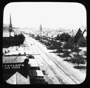 City of Ballarat Libraries
Glass Slide, Sturt St looking east from City Fire Brigade tower
Tram tracks can be clearly seen in this image. Horse trams were introduced late in 1887, the line up Sturt St to the Lake and Gardens being built first. Note these tracks do not have any electricity above them - electric trams did not appear until 1905. St Andrews Kirk steeple was erected in 1884.Previously unknown image of Ballarat. The set and its subjects indicate these images were produced to promote Ballarat and were perhaps aimed at tourists.An image repeating von Guerard's famous drawing from the City Fire Brigade tower, looking east along Sturt St to Mt Warrenheip. -
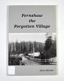 Marysville & District Historical Society
Book - Paperback book, Alma Mitchell, Fernshaw the Forgotten Village, 2001
The story of the village of Fernshaw between the dates of 1864 and 1890.Paperback. Front cover has the title and author's name. Also, a black and white photograph taken by John W. Lindt entitled 'First Glimpse of Fernshaw'.non-fictionThe story of the village of Fernshaw between the dates of 1864 and 1890.fernshaw, victoria, history, watts river, yarra track